
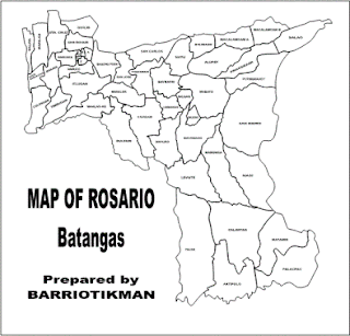
The Municipality of Rosario, Batangas, Philippines is situated at the southeastern portion of Batangas Province along with its southeastern boundaries with Quezon Province.
Rosario, Batangas is bounded on the north by the Municipality of Padre Garcia and Lipa City; on the south by the Municipality of Taysan and the Municipality of Lobo; on the east by the Municipality of San Juan and Quezon Province; and on the west by the Municipality of Ibaan.
Rosario, Batangas consists of 48 barangays. Five of these barangays -- Poblacion A, B, C, D and E, are classified urban barangays with a total land area of 93.1 hectares. The remaining 43 barangays of Rosario, Batangas with a total land area of 278.3 square kilometers are considered rural barangays.
Map of Rosario Batangas
Socio-Economic Profile
This post last updated: 26 December 2011


No comments:
Post a Comment